
Land Navigation
Supplemental Mapwork
Unit Conversion Table
| 1 meter | = | 3.28 feet |
| 1 inch | = | 2.54 centimeters |
| 1 mile | = | 5280 feet |
| 1 kilometer | = | 1000 meters |
| 1 degree | = | 60 minutes |
| 1 minute | = | 60 seconds |
Tools
In order to complete this supplemental coursework you will need some basic tools. These items are included in the navigation kit that you will receive at Course B. However, if you have not yet received your navigation kit then these printable versions will be sufficient for now.
Pencil - Pencils are preferable because you may need to make corrections or revise your plan.
Ruler - A tenths ruler makes calculations easier than a standard ruler. Tenths Ruler PDF (download)
Protractor - A 360° protractor, clear is preferable. Protractor PDF (download)
Calculator - A basic calculator for doing simple math.
Coordinate Systems
The most common coordinate systems used in search and rescue are Latidude/Longitude and UTM. For the purposes of this supplemental coursework we will stick to these and assume the WGS-84 datum. Below is some useful information to review. There are plenty of resources available online if you want to delve into more detail or learn about other coordinate systems.
Latitude/Longitude
Coordinates in Latitude and Longitude are expressed as some combination of Degrees, Minutes, and Seconds. There are 60 minutes in a degree, and 60 seconds in a minute. You can convert between formats using simple division and multiplication. You are likely to encounter them in the following formats:
- N47.5068° W121.7390° - Degrees Only (“Decimal Degrees”)
- N47°30.408' W121°44.341' - Degrees and Minutes (“Degrees Decimal Minutes”)
- N47°30'24" W121°44'20" - Degrees, Minutes, and Seconds (“Degrees Minutes Seconds”)
Universal Transverse Mercator (UTM)
Coordinates in UTM are expressed in meters and in the context of a Grid Zone. The Grid Zone is determined based on a system of “Zones” and longitudinal “Bands”. For the purposes of this coursework it is sufficient to know that ESAR's primary area of operations lies in the 10T Grid Zone. UTM coordinates describe a position within the Grid Zone as an Easting and Northing; the distance, in meters, east and north from the southwest corner of the Grid Zone:
- 10T 0549596E 5262255N - Grid Zone, Easting, and Northing
Units of Measurement
Question
Convert 5 centimeters to inches.
Show / Hide Answer
Question
Convert 3.4 inches to centimeters.
Show / Hide Answer
Question
How many kilometers is 1 mile?
Show / Hide Answer
Question
You are riding with 4x4 to your assignment location. The assignment begins 1100 meters past a forest service gate. The 4x4 driver can use their trip meter to help determine how far to drive. How many tenths of a mile should they drive?
Show / Hide Answer
Question
You are hiking to your assignment location. The assignment begins 2.5 miles past a forest service gate. How many kilometers will you be hiking?
Show / Hide Answer
Coordinate Systems
Question
How many Minutes is 54.6 Seconds?
Show / Hide Answer
Question
How many Seconds is 0.70 Minutes?
Show / Hide Answer
Question
How many Minutes is 0.8059 Degrees?
Show / Hide Answer
Question
Convert N47.4880° W121.7232° to Degrees Decimal Minutes.
Show / Hide Answer
Question
Convert N47°32'28.1" W122°10'28.2" to Decimal Degress.
Show / Hide Answer
Pacing
Pacing is a method to keep track of distance. A pace is the distance that you travel while walking each time the same foot hits the ground. For example, if you lead (take your first step) with your left foot, then you will count a pace each time your right foot touches the ground. For the purposes of ESAR Basic Training we generally refer to pace in terms of feet.
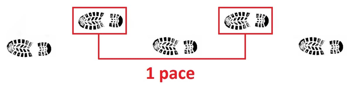
To determine your pace you can measure out a known distance (for example 1000 feet) and walk that distance counting your paces. Then divide the distance by the number of paces to get your pace length. For example if you walked 1000 feet in 200 paces then your pace length is 5 feet per pace. You can use this information to estimate distances while navigating.
Question
Joe is calculating his pace. If he walks 1000 feet in 196 paces, what is the length of his pace?
Show / Hide Answer
Question
Susan's pace is 4.5 feet. If she needs to travel 1140 feet how many paces does she need to take?
Show / Hide Answer
Question
Michael's pace is 4.8 feet. If he needs to travel 235 meters how many paces does he need to take?
Show / Hide Answer
Question
Megan and Zoe have partnered for a compass run. Megan's pace is 4.7 feet and Zoe's pace is 5.25 feet. During the compass run both Megan and Zoe were counting their paces, but Zoe forgot what her count was. They stop to confer. Megan has counted 57 paces so far. If Zoe returns to Megan's position, what should her current pace count be?
Show / Hide Answer
Mapping Problems
In order to complete this set of problems you will need to print and familiarize yourself with The Map (download)
Question
Plot 10T 0619350E 5253637N
Show / Hide Answer
Question
Plot 10T 0619708E 5252790N
Show / Hide Answer
Question
Plot 10T 0619693E 5253869N
Show / Hide Answer
Question
Plot 10T 0619083E 5253522N
Show / Hide Answer
Question
Plot 10T 0619104E 5252818N
Show / Hide Answer
Question
Plot 10T 0619047E 5253858N
Show / Hide Answer
Question
From the intersection at 10T 0619742E 5252932N walk northbound on the road for 290m.
Show / Hide Answer
Question
Follow the Dodge Ridge Chairlift uphill until you reach 3160ft elevation, then travel 355ft on a bearing of 186°